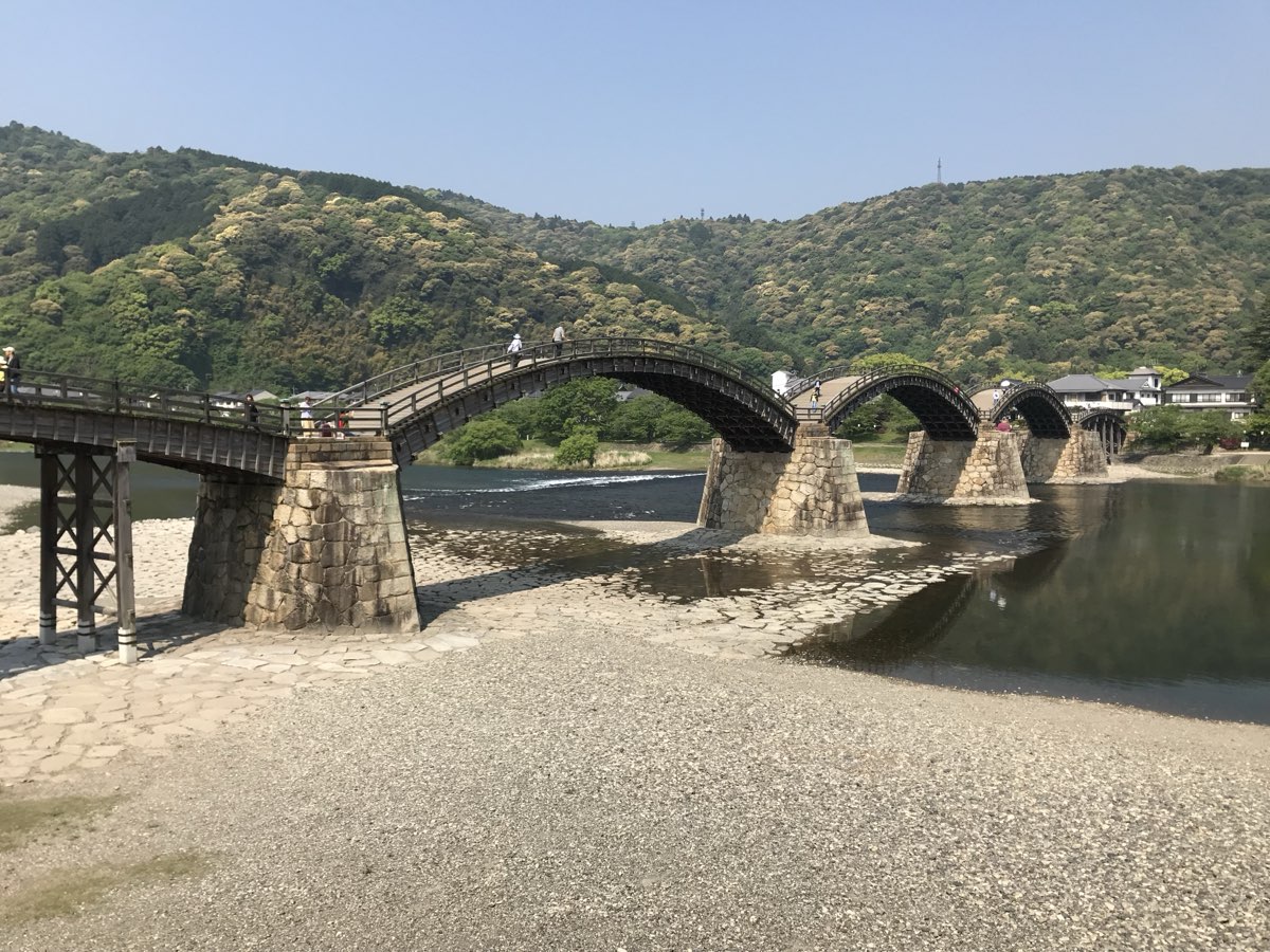
The Kintai Bridge crosses the Nishiki River in Iwakuni, in the east of Yamaguchi Prefecture. It is made of five wooden spans resting on four stone piers, and it was designated a national Place of Scenic Beauty in 1922.
The bridge was first built in 1673 by Kikkawa Hiroyoshi, the third lord of Iwakuni. Since then it has been taken apart and rebuilt many times, and floods have carried it away twice. This article follows how the bridge came to be, how it was kept standing, and how it was rebuilt after it was lost in 1950.
A town divided by a river
After 1600 the Kikkawa family received the eastern part of Suō Province, including part of today's Iwakuni. According to a 2018 proposal by Yamaguchi Prefecture and Iwakuni City, Kikkawa Hiroie began building a castle town in 1602.
He placed a castle on the summit of Mount Yokoyama and used the Nishiki River, which wraps around the mountain, as a natural moat. The lord's residence, government offices and senior retainers were on the Yokoyama side.
Lower-ranking retainers and townspeople lived across the river in Nishimi. The castle on the summit was demolished in 1615 under the rule allowing only one castle per province.
Governing a town split in two required a bridge. The proposal describes the Nishiki as a violent river: about 200 meters wide at the bridge site, and able to rise more than 7 meters in a flood. Girder bridges, the usual type in Japan at the time, were washed away again and again by sediment, driftwood and scouring of the riverbed.
The second lord, Kikkawa Hiromasa, began building a bridge in the third month of 1657 (lunar calendar) and held the first crossing in the ninth month. In the fifth month of 1659 a flood carried it away.
An idea from a book about West Lake
The third lord, Hiroyoshi, set out to build a bridge that floods could not wash away. According to Iwakuni sources, he obtained a book about West Lake in China from Duli (Dokuryū), a monk from Ming China.
Its pictures showed arch bridges linking small islands. Hiroyoshi is said to have taken from it the idea of building strong, island-like piers in the river and linking them with bridges.
Work began in 1673. To build piers that no flood could break, the builders laid frames of green pine logs 2 to 2.7 meters below the riverbed and raised stone walls on top of them. They filled the inside with rubble and clay.
The bridge was finished on the night of the first day of the tenth month of 1673 (lunar calendar), and people began crossing on the third. On the twenty-eighth day of the fifth month of the next year, 1674, a flood washed it away. Rebuilding began on the first day of the sixth month, and the first crossing of the new bridge took place on the third day of the eleventh month.
Arches made of small timbers
The two end spans are girder bridges carried on wooden posts, while the three central spans have no posts. The Agency for Cultural Affairs notes that the bridge is known for its unusual vaulted form.
Each arch is built from fairly short timbers, about 6 to 8 meters long and only about 170 millimeters square in section. According to the proposal, the builders stacked them, shifting each layer forward by about a third of its length. They bound them together with iron bands, dowels and clamps and filled the gaps with wedges, so that the stacked timbers worked as one large arch.
Yamaguchi Prefecture describes the structure of the three central arches as having no parallel anywhere in the world. The prefecture also counts today's bridge as the fourth.
The riverbed itself is part of the design. The national designation describes stone paving laid on the riverbed upstream and downstream of the bridge. According to the proposal, its purpose was to stop the riverbed from being scoured and to protect the piers.
Keeping a wooden bridge standing
A wooden bridge rots, so the Kintai Bridge had to be repaired and rebuilt regularly. According to the proposal, a levy for this purpose is said to have been collected from 1675 from everyone in the domain, from samurai to townspeople. From 1678 it became a permanent tax, called hashidashimai, which lasted until the domains were abolished in 1871.
The bridge was not open to everyone. Iwakuni City explains that bridge keepers were posted at both ends, and passage appears to have been strictly controlled.
By the early nineteenth century the rules had eased, and more travelers came to see the bridge. In the Meiji era, after the domains were abolished, the bridge keepers were abolished and people could cross freely.
Knowledge of how to build the bridge was passed on through drawings and through the work itself. Twelve drawings from the Edo period survive, the oldest from a rebuilding in 1699, along with full-size templates from later times. Because the bridge was rebuilt so often, many carpenters gained experience in building it.
The bridge also became a famous sight. It appears in woodblock prints by Katsushika Hokusai (1831) and Utagawa Hiroshige (1853).
The loss of 1950 and the rebuilding
According to the proposal, after the rebuilding of 1674 the bridge was not washed away for 276 years. In 1950 the Kijia typhoon caused the piers to collapse, and the bridge was carried away.
As in earlier floods, residents placed large barrels on the bridge and filled them with water, hoping the weight would hold it in place. The bridge was lost while many residents watched.
On the same day, the Iwakuni city council passed a resolution to rebuild. The proposal explains that residents' wishes supported rebuilding with traditional methods rather than with cheaper and easier modern methods, such as a steel bridge.
Work began in 1951 and was completed in 1953. According to the proposal, it took about two years, about 69,000 person-days of labor and 120 million yen.
The rebuilding kept the traditional form of the wooden arches. For safety, however, the piers were rebuilt in reinforced concrete, faced with stones from the old piers. The proposal calls these the biggest changes in the bridge's history.
All five spans were rebuilt again in what is called the Heisei rebuilding. The World Heritage proposal and the promotion council's leaflet date this work to 2001–2004, while an Iwakuni City page says the present wooden structure was rebuilt from 2001 to 2003.
The bridge today
Iwakuni City owns and manages the bridge and checks it regularly, including a survey of decay every five years. In 2021, the "Cultural Landscape of the Kintai Bridge and Iwakuni Castle Town in the Lower Nishiki River" was selected as a national Important Cultural Landscape.
In 2018 Yamaguchi Prefecture and Iwakuni City prepared a proposal for adding the bridge to Japan's World Heritage Tentative List, and a promotion council with its office at Iwakuni City continues to work toward World Heritage status. The bridge is not a World Heritage Site.
Places to visit
The Kintai Bridge itself can be crossed on foot. Iwakuni City notes that a fee is charged to cover the costs of rebuilding and maintenance. Check the official website for current details before visiting.
The bridge links the two halves of the old castle town: Yokoyama, where the lord's residence and senior retainers were, and Nishimi across the river. The cultural landscape selected in 2021 takes in both the bridge and the Iwakuni castle town.
Sources
- 錦帯橋Agency for Cultural Affairs (Cultural Heritage Online)
- 道路こぼればなし1Iwakuni City
- 山口まめ知識Yamaguchi Prefecture (Public Relations Division)
- 世界遺産暫定一覧表記載資産候補提案書 錦帯橋(平成30年12月)Yamaguchi Prefecture and Iwakuni City
- 錦帯橋 世界遺産をめざして(リーフレット)Kintaikyo World Cultural Heritage Registration Promotion Council (錦帯橋世界文化遺産登録推進協議会), Iwakuni City